Silverboss Property
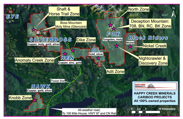
The Silverboss property is located approximately 85 kilometres northeast of 100 Mile House in south central British Columbia. The property is approximately 155 square kilometres in area and is 100% owned by Happy Creek Minerals Ltd. It is the first time one Company has obtained this strategic land position around the former Boss Mountain molybdenum mine mine property, locally within 350 metres of one of the existing open pits. Under NI43-101 (2001), the reader is cautioned that results or information from an adjacent property does not infer or indicate similar results or information will or does occur on the subject property. Historical information cannot not be relied upon as the Company’s QP, a term which was created and defined under NI-43-101 has not prepared nor verified the historical information.
SILVERBOSS PROPERTY FACTS
| Property | 9,001 hectares or 90 square kilometres of mineral tenure |
| Ownership | 100% Happy Creek Minerals Ltd. since 2006 |
| Key minerals present | molybdenum, copper, gold, silver, tungsten |
| Location | 85 km northeast of 100 Mile House, south central British Columbia, Canada |
| Access | Via paved and gravel roads from 100 Mile House |
| Closest mine | Former Boss Mountain molybdenum mine |
| Surveys completed | Prospecting, geology, geochemical, geophysical |
| Sample database | 214 silt, 171 rock, 3263 soil |
| Geohysics | 3D IP andf magnetic at Silverboss Shaft and Horsetrail zones |
| Prospects | |
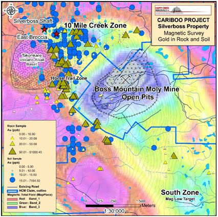
| Silverboss.Shaft | Rock samples up to 9.25 g/t gold, 514.8 g/t silver over 0.25 metres and 2.52 percent copper, 6.21 g/t gold, 295 g/t silver and 6.76 g/t indium in grab samples. Strong and larger IP at depth than surface |
| Horse Trail | Rock samples ranging from 0.10 to 1.69% copper, and 0.108 to 0.637% molybdenum, and 1.03 to 10.0 g/t gold. Strong IP response at depth |
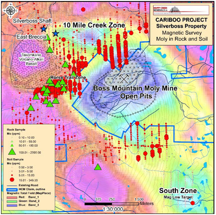
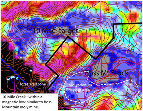
| 10 Mile Creek | A 25 metre grab sample assayed 0.05% tungsten. This area is within an airborne magnetic low on the north side of Boss Mountain mine. |
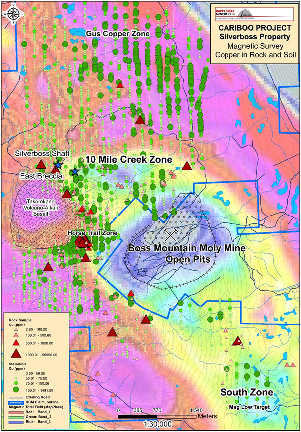
| Gus copper | Positive copper geochemical anomaly that is approximately 1.2 kilometres by 600 metres in dimension. |
| Project Stage | Exploration. Several targets ready for drilling. Additional targets in exploration stage |
| Services | 45 min drive to asphalt road, Village of Forest Grove and town of 100 Mile House provide most services required. |
Happy Creek Minerals has performed prospecting, systematic silt, soil and rock geochemical and geophysical surveys and geology. This has outlined several large scale copper-molybdenum-gold-silver targets. The Silverboss Shaft and Horse Trail zones are considered targets that are drill-ready. Other targets require geophysical or geochemical surveys to define drill targets.
History
The adjacent Boss Mountain molybdenum mine was developed and operated by Noranda Inc. between 1965 and 1983. It was closed in 1984 due to continued low molybdenum prices. It was Canada's first primary molybdenum mine, with a high average grade (0.20% molybdenum). During the mine's development and operation, very limited exploration was performed beyond the known deposits.
Between 2005 and 2014, Happy Creek carried out prospecting and systematic stream sediment, soil and rock geochemical surveys expanding outward from the perimeter of the mine property. Routine analyses for gold and other pathfinder elements were performed that were not done historically.
Between 2005 and 2014, Happy Creek carried out prospecting and systematic stream sediment, soil and rock geochemical surveys expanding outward from the perimeter of the mine property. Routine analyses for gold and other pathfinder elements were performed that were not done historically.
Prospects
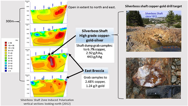
The historical Silverboss shaft zone consists of a shear and quartz stockwork system at surface, 1.0 to 3.0 metres in width that has been traced on surface for 350 metres. Rock sampling of this zone has returned values of 9.25 g/t gold, 514.8 g/t silver over 0.25 metres and 2.52 percent copper, 6.21 g/t gold, 295 g/t silver and 6.76 g/t indium in grab samples. Approximately 300 metres to the east of the Silverboss shaft, a grab sample returned 1.24 g/t gold and 2.48% copper at the East Breccia zone located on the edge of the 10 Mile Creek area. Further north, a grab sample of quartz float with pyrite and chalcopyrite returned 0.41 g/t gold, 180 g/t silver and 1.8% copper. Positive copper, gold and silver values in soil and rock samples occur well beyond the Silverboss shaft zone. A 3DIP geophysical survey has returned results that suggest the copper-gold-silver mineralization at surface extends to depth where it shows a much larger geophysical target. Diamond drilling is proposed to test for copper-gold mineralization.
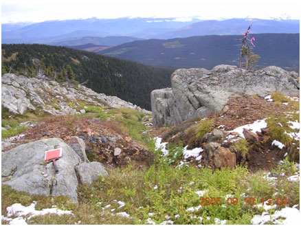
 Horse Trail Zone
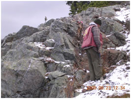
Located to the west of the mine's molybdenum deposits, the Horse Trail zone returned positive copper, molybdenum and gold in soil and rock samples. Numerous rock grab samples of quartz veins have returned values from 0.10 to 1.69% copper, 0.108 to 0.637% molybdenum and 1.03 to 10.0 g/t gold. These mineralized quartz veins are thought to be part of a large scale structure extending beyond the mine's deposits and onto the Silverboss property. An induced polarization (IP) and magnetic survey performed in 2011 that indicated potential for mineralization to occur below surface. Diamond drilling is proposed to test for copper-molybdenum-gold mineralization.
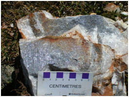
Molybdenite, and copper-gold in quartz veins at Horse Trail zone
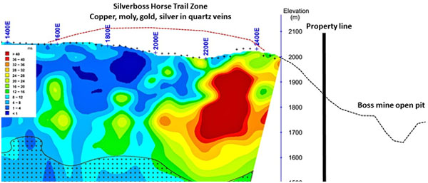 Horse Trail zone 3D IP section viewing t…
 10 Mile Creek
To the north of the mine’s molybdenum deposits, in the 10 Mile Creek area, an airborne magnetic geophysical "low" occurs that is adjacent a similar one that outlines the Boss Mountain stock and associated molybdenum deposits (biotite alteration?). In 10 Mile Creek, an outcrop contains over 0.20% molybdenum is located on the north side of the Boss Mountain stock. This area is largely covered by glacial till however outcrops of intrusive breccia, pyrite and positive tungsten and molybdenum values occur. A 25 metre grab sample assayed 0.05% tungsten (0.063% W03). Tungsten is a metal that is often associated with molybdenum (see the Company’s Fox property). An induced polarization geophysical survey is proposed to help identify underlying copper-molybdenum-gold sulphide mineralization.
Dogtooth
Between the Horse Trail and Silverboss shaft zones, and at higher elevations to the west of the 10 Mile Creek area, the Company's systematic approach has outlined a new gold-silver zone that is slightly outside of the molybdenum system. Numerous narrow quartz veins in and around the Dogtooth zone have returned values of 0.30 to 5.0 g/t gold and up to 53.01 g/t gold, 343.0 g/t silver in grab samples and 9.29 g/t gold, 27.3 g/t silver over 1.17 metres in width. These widespread gold-bearing, often vuggy or “dogtooth” style quartz veins and positive gold in soil occur in an area approximately 1.6 by 1.2 kilometres in dimension that is considered to be a previously unrecognized bulk tonnage gold-silver target. An induced polarization geophysical survey is proposed to help identify underlying copper and or gold sulphide mineralization, followed by diamond drill testing.
 Dogtooth zone- samples up to 50.0 g/t go…
The northern portion of the Silverboss property has historically received very little exploration. Between 2008 and 2011, Happy Creeks' systematic surveys were expanded to the north which identified a positive copper geochemical anomaly that is approximately 2 kilometres by 600 metres in dimension and occurs within rocks having higher magnetics as seen in the airborne survey. At the southern end of this large geochemical anomaly, a boulder of propylitic altered hornblende diorite contains pyrite and chalcopyrite and returned 0.15% copper, 0.06 g/t gold. At the northern end of the geochemical anomaly, the Gus prospect is reported to comprise disseminated pyrite and minor chalcopyrite in a porphyritic diorite. No further work is known for this large scale copper in soil (refer to property copper in soil map). An induced polarization geophysical survey is proposed to help identify underlying copper sulphide mineralization. The southern end of the Silverboss property has an airborne magnetic low, similar to that at the mine and 10 Mile Creek. In 2008, the Company performed a reconnaissance soil sample survey in a portion of this area which returned a linear zone of positive copper in soil. In 2014, recent logging roads and clear cuts allowed much greater access and a view of this area not previously seen. The area was all underlain by thick glacial till. Only boulders with weak to locally moderate chlorite-epidote and sericite alteration along with pyrite and trace chalcopyrite were visible at surface, with samples containing low copper-gold values. The best sample returned 0.52% copper, 0.20 g/t gold, 11.0 g/t silver and 8.6 ppm molybdenum. An induced polarization geophysical survey is proposed to help identify underlying copper or molybdenum sulphide mineralization.
Geology
Boss Mountain molybdenum mine Geology
Geology of the Boss Mountain mine is described here, largely summarized after Soregaroli, 1976 and MacDonald, 1995. The Boss Mountain Stock, monzogranite in composition and Middle Cretaceous in age (approximately 98-105 Ma) cuts the Boss Creek unit of the Takomkane Batholith, granodiorite to quartz monzodiorite in composition and Upper Triassic-Lower Jurassic in age.
Molybdenum deposits at the Boss Mountain Mine are located peripheral to, or on the flanks of the Boss Mountain monzogranite stock. Felsic (rhyolite) and mafic tholeiitic, alkali basalt dikes cut monzogranite and the Takomkane Batholith and occur in spatial proximity with the quartz matrix breccia and quartz veins comprising the molybdenum deposits.
Early stage coarse-grained molybdenite bearing quartz veins comprise a sheeted vein complex comprised of quartz, orthoclase pyrite and molybdenite with minor sericite and rutile, very minor biotite, amphibole and topaz. Vugs contain zeolite, calcite, siderite, clay and rarely fluorite. A second phase of quartz veins contains no molybdenum, however, lead-copper-bismuth sulphides, bismuthinite, chalcopyrite, sphalerite, galena, scheelite and anatase occur locally within the same structures as the coarse-grained molybdenum veins. These second phase quartz veins are first to cut the Boss Mountain stock, and have envelopes of k-feldspar and sericite up to 50 centimetres. Molybdenum-rich veins locally occur within the same structures hosting dikes.
Ribbon style quartz molybdenum veins occur in areas hosting other quartz veins and within the same structures hosting mafic dikes. Locally porphyritic felsic dikes cut these veins sets.
Silverboss Geology
The Silverboss property is underlain by the Takomkane Batholith. Intrusive rocks vary from medium grained, grey, biotite-hornblende diorite, quartz diorite, monzodiorite and quartz monzodiorite/granodiorite in composition. Mafic rocks comprised of generally diorite, gabbro and pyroxenite occur along the northeast side of the Silverboss property, underlying the Gus geochemical anomaly and marks the outer boundary of the Takomkane Batholith. Xenoliths of diorite in granodiorite occur and form coarse breccia textures, locally in proximity with intrusive contacts and dykes. Dark, angular magnetic diorite fragments in heterolithic intrusion breccia and andesite porphyry dykes occur near the Silverboss shaft, and granite/monzonite fragments occur within biotite-hornblende diorite south of 10 Mile Creek. The 10 Mile Creek area is located near the inferred northern contact of the Boss Mountain monzogranite stock. Based on a similar magnetic low, positive tungsten values in rock, and positive molybdenum in soil and stream sediment, a separate stock is inferred to occur beneath the 10 Mile Creek area. All of the rocks are cut by dominantly west-northwest to north trending steeply dipping dykes of tholeiitic andesite composition, 0.5 to 3.0 metres in width, and locally more felsic dykes of possible rhyolite composition occur. These dykes occur in proximity to the known molybdenum deposits and have been identified by mapping two kilometres beyond the deposits and through the Silverboss property. Widespread and locally concentrated fracture zones contain quartz, chlorite, epidote, tourmaline, sericite, clay, carbonate, k-feldspar, biotite, and locally diopside/pyroxene that variably replace mafic minerals and plagioclase within vein selvages, intrusion breccia matrix and in the wall rocks of fractures. Quartz veins on the Silverboss property are in part similar in description, size and nature of occurrence to some of the quartz veins associated with the adjacent Boss Mountain mine, in particular where andesite dikes occur. Although differences in textures, metal ratios and metal content occur, Silverboss quartz veins and those at the mine frequently contain tungsten and bismuth trace elements, that are thought to be related to the mid Cretaceous Boss Mountain stock, or other similar stocks in the area. Similarly, Happy Creek's Fox property located 25 kilometres to the east also contains a mid-Cretaceous aged stock and associated tungsten, molybdenum and bismuth mineralization.
A Recent-Holocene aged peridote bearing olivine alkaline basalt volcanic neck and peripheral ash, tephra and flow cut and overlie all rocks at the summit of Big Timothy Mountain. Beneath the relatively thin lava and cinder flows, the Horse Trail copper-molybdenum-gold-silver zone remains open in extent to the west and north.
A Recent-Holocene aged peridote bearing olivine alkaline basalt volcanic neck and peripheral ash, tephra and flow cut and overlie all rocks at the summit of Big Timothy Mountain. Beneath the relatively thin lava and cinder flows, the Horse Trail copper-molybdenum-gold-silver zone remains open in extent to the west and north.