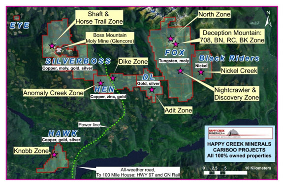
Hen Art-Dl Property
The Hen and Art-DL property is located about 16 kilometres southeast of the Boss Mt. molybdenum mine, and 57 kilometres northeast of 100 Mile House in the south Central Cariboo region of British Columbia, Canada. The property adjoins the Company's Silverboss and Fox properties to the south and west, respectively.
The key prospects include, from west to east:
- Anomaly Creek (porphyry style copper, zinc, gold)
- Hen, Dyke and Ledge (calcic skarn gold)
- Art and DL (Adit) (sediment-hosted, orogenic gold+/- silver)
Under NI43-101 (2001), the reader is cautioned that results or information from an adjacent property does not infer or indicate similar results or information will or does occur on the subject property. Historical information from the subject or adjacent property cannot not be relied upon as the Company’s QP, a term which was created and defined under NI-43-101 has not prepared nor verified the historical information.
| Property | 6,266 hectares or 62 square kilometres of mineral tenure |
| Ownership | 100% Happy Creek Minerals Ltd. since 2006 |
| Key minerals present | Gold, silver, zinc, copper |
| Location | 36 km northeast of 100 Mile House, south central British Columbia, Canada |
| Access | Via paved and gravel roads from 100 Mile House |
| Closest mine | Former Boss Mountain molybdenum mine |
| Surveys completed | Prospecting, geology, geochemical, geophysical, machine trenching, diamond drilling |
| Sample database | 232 silt, 93 rock, 498 soil Best rock samples: DL 10.2 g/t Au, 17.3 g/t Ag, 42.0 g/t Au DL 20.1 g/t Au, 13.0 g/t Ag Hen: 2.1 g/t Au, 2.8 g/t Ag Hen- dyke: 35.0 g/t Au, 6.2 g/t Ag Anomaly Creek: 0.29% Cu, 51.2 ppb Au, 0.09% Cu, 0.82 g/t Au, 0.35% Cu, 0.04 g/t gold, 2.8 g/t silver, 0.10% zinc and 0.07% lead |
| Geohysical surveys | 3D IP and magnetic on Anomaly Creek, Max-Min-EM/mag on Ledge , airborne radiometric and magnetic |
| Machine Trenching | 1993 Hen original /main zone 4 trenches totalling approximately 210 metres Trench B 2.1m 3.98 g/t Au 2009: -22 trenches totalling 541.0 m Dyke zone Hen T-16: 4.0 m 2.08 g/t Au Hen T-16 a 2.0m 4.2 g/t Au Hen- Ledge Zone T-13 28.0m 0.04% As. 0.02 g/t Au Hen-Ledge zone T-14 36.0 m 0.03% As T-14 end of trench 4.0m 0.11% As, 0.12 g/t Au Hen-Anomaly Creek T-5 26.0m 0.07% Zn, T-11 44.0m 0.04% Zn |
| Drilling | 1994: Hen:original zone: 2 holes 199.4m Hen 94-1: 8.0m 0.80 g/t Au, 1.6m 1.0 g/t Au 1996: Hen original zone 2 holes 470.0m Hen 96-3 0.8m 2.0 g/t Au 1999- 2 holes totalling 434.2m tested a high magnetic zone beneath a swamp in Ledge prospect area. 2001: DL 3 holes 270.66m 3.0M 1.0 g/t Au 2001 ART: 3 holes 210.91m DH 01-2 12.0m 0.167 g/t Au, 0.35% As 2010 DL 5 holes 800.1 m 2010-GL-3 72.5 m 4.0 g/t Ag including 20.0 m 8.5 g/t Ag and up to 0.28 g/t gold |
| DL adit | 1800’s – large quartz vein in black phyllite with pyrite, trace sphalerite, galena. |
| Project Stage | Exploration. Several targets ready for drilling. Additional targets in exploration stage |
| Services | 30 min drive to asphalt road, Village of Forest Grove and town of 100 Mile House provide most services required. |
Key prospects from west to east
At the Anomaly Creek zone, the Company has outlined a one square kilometre area containing positive silt, soil and rock and trench geochemical anomalies of zinc, copper, manganese, gold and silver and a coincident positive induced polarization geophysical anomaly. Copper and zinc values appear to be greatest within or adjacent the Boss Creek unit of the Takomkane Batholith on the western side of the Anomaly creek zone.
Together, the Hen, Dyke and Ledge zones comprise calcic gold skarn prospects associated with pathfinder elements arsenic, over a distance of approximately 4 kilometres that is largely underexplored. The gold values and width of mineralized zones at the Hen and Dyke zones are similar, and are over 1.0 km apart, On the Ledge prospect, Trench T-14 returned 4.0 metres grading 0.12 g/t gold and 0.11 percent arsenic that remains open in extent.
The DL prospect is centered on an adit (a tunnel with only one entrance), which dates back to the 1880's. Here, rock samples have returned up to 42.9 g/t gold, 34.7 g/t silver over 1.0 metre. The Art prospect is located approximately two kilometres to the west. The property shares many similarities to the orogenic, sediment-hosted gold-silver model including the Thunder Ridge and Spanish Mountain prospects 1.5 kilometres to the south and 100 kilometres to the north, respectively.
Geology
Hen
The Hen property is underlain by the Nicola Group, Upper Triassic in age, that consists here of predominantly volcanic and calcareous sandstone of the Nicola volcaniclastic succession, and coarser volcanic breccia and mafic flow units occur to the north of the Hen-Dyke and Ledge prospects, and to the west at the Anomaly Creek prospect. At the Anomaly Creek zone, these volcanic rocks occur in north trending contact with the Boss Creek units of the Takomkane batholith. Schiarizza and Macauley, (Fieldwork, 2006, Paper 2007-1) explain that rocks assigned to the Boss Creek unit occur over much of the north eastern part of the Takomkane batholith. This unit consists mainly of light grey, medium to coarse grained, equigranular rocks of predominantly quartz monzodiorite composition, but monzodiorite, granodiorite, quartz diorite, diorite and tonalite are also present. Mafic minerals commonly form 15 to 25% of the rock, and include varying proportions of clinopyroxene, hornblende and biotite.
Dykes of diorite to monzonite composition cut the volcanic and sedimentary rocks in the Anomaly Creek zone. The intrusive rock is locally altered to biotite, chlorite, epidote, magnetite, quartz and k-feldspar +/- trace tourmaline occurs in fractures and trace pyrite, chalcopyrite and bornite occur. Volcanic and sedimentary rocks are moderate to strongly biotite altered, fractured and contain variable amounts of dominantly quartz and sericite that are either in veinlets or replace the rock matrix. Trace to 15% pyrite, pyrrhotite and variable concentrations of gypsum, sphalerite, galena and trace chalcopyrite occur.
To the east, at the Hen, Dyke and Ledge prospects, the volcanic sediments are in east trending contact with a biotite-hornblende monzogranite to granodiorite stock, early Cretaceous in age (104.9 +/-1.9 Ma-Million years), for four kilometres adjacent to the Hen, Dyke and Ledge zones. This age is similar to that of the Boss Mountain stock (98-105 Ma) that is associated with the molybdenum deposits at Boss Mountain mine to the north.
The geological contact between volcanic and the easterly trending intrusive is locally irregular in shape, and dikes or sills occur up to several hundred metres from the moderately north dipping contact. Rocks within approximately one kilometre of the stock contact are strongly biotite-hornfelsed, contain between 1-5% pyrrhotite, pyrite, trace chalcopyrite and trace to 3% arsenopyrite. Dominant structures trend around 110 azimuth, generally subparallel to the intrusive contact. A petrographic report indicates the calc-silicate alteration consists of banded quartz, actinolite, tremolite, epidote, biotite, carbonate, k-feldspar, clinopyroxene, and pyrrhotite, chalcopyrite and arsenopyrite. Ilmenite, rutile, actinolite and possible scapolite, wollastonite and diopside have also been identified. Locally, up to 10% pyrrhotite occurs in calcareous volcanic rock and red garnet occurs locally in carbonate veins. Variable concentrations of disseminated and stringers of pyrrhotite, chalcopyrite, sphalerite, arsenopyrite and possibly stibnite(?) occur within the hornfels and calc-silicate zones. Gold and silver values occur with highly variable concentrations of copper, molybdenum, arsenic, zinc and antimony trace elements. The presence of molybdenum and an adjacent intrusive rock that is similar in age to the Boss Mountain molybdenum mine to the north is an interesting association.
The geology and alteration associated with positive gold values suggest the Hen, Dyke and Ledge prospects contain gold-bearing pyroxene, calcic skarn zones over a distance of four kilometres in proximity to an intrusive contact.
 Hen- Dyke Zone T-16 4.0m of 2.0 g/t gold…
 ART-DL
The key geological aspect of the Art and DL prospects is that they cover a portion of the Eureka Thrust, a continental-scale fault between the Quesnel terrane, a volcanic island arc, Upper Triassic-Lower Jurassic in age to the west, and the older continental shelf sediments comprised of the Snowshoe Formation, Paleozoic in age, to the east. The Thunder Ridge prospect, located 1.5 kilometres to the south is within the same geology and drilling has discovered multiple zones containing positive to significant gold. The geological setting of the DL prospect is also similar to the Spanish Mountain and Frasergold deposits located 40 to 100 kilometres to the north.
At the Art prospect, hornblende-biotite-quartz-feldspar porphyry cuts Nicola Group fine grained volcanic tuff and flow of basalt to andesite composition and widespread quartz sericite-carbonate, green mica (mariposite) and hematite alteration occurs. Quartz and quartz carbonate veins contain ankerite, pyrite, pyrrhotite and arsenopyrite and trace chalcopyrite and sphalerite. Shear zones containing up to 10 percent sulphide occurs. Diamond drill hole ART01-1 returned 3500 ppm (0.35%) arsenic with 0.17g/t gold over 12 metres and grab samples from nearby outcrops contain up to 1.27 g/t gold. Several other positive gold and arsenic soil and rock geochemical anomalies occur to the north of this area, and much of the property remains unexplored. This style of mineralization appears similar to that found at the Company's Hen property located approximately two kilometres to the west. These wide-spread, positive gold geochemical anomalies and associated pathfinder trace elements are thought to indicate potential for a large scale, precious metal system.
The DL adit zone is comprised of a gently plunging saddle reef-style quartz vein, hosted by black graphitic, porphyroblastic or 'knotted" phyllite. Numerous quartz veins occur that are structurally controlled and re-folded, and a minimum of two generations of quartz and quartz-carbonate veins have been noted. Northwest of the adit, fine grained dykes of possible latite to aplite composition contain pyrite, trace arsenopyrite and stibnite (arsenic and antimony sulphides, respectively).Rocks are well foliated, weakly metamorphosed dark grey graphitic argillite and light-medium grey siliceous siltstone with variable argillite to siltstone ratio from 90:10 to 50:50. Quartz-iron carbonate+/- sulfide (pyrite, pyrrhotite, and sphalerite) veins and stock work occur throughout, and are hairline to rarely greater than 1.0 metres width, and average about 1 to 5% of the sequence. Diamond drilling to the south of the DL adit in 2010 intersected mainly silver mineralization within the quartz-carbonate stock-work zones. Intervals include 20.0 metres of 8.5 g/t silver.
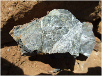
 Art prospect: pyrite +/- arsenopyrite in…
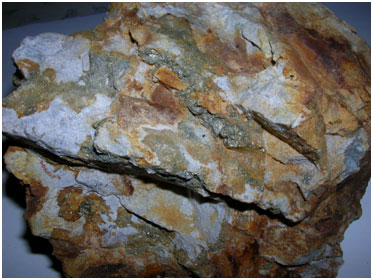
 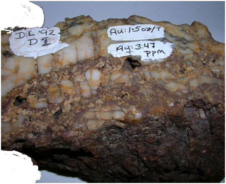 DL adit Quartz vein in black phyllite: s…